Conny Waters – AncientPages.com – Monte Sierpe (also known as the Band of Holes), meaning “serpent mountain,” is a remarkable archaeological site in the Pisco Valley of the southern Peruvian Andes. Spanning 1.5 kilometers, it features approximately 5,200 precisely aligned holes, each measuring 1 to 2 meters wide and 0.5 to 1 meter deep, arranged in distinct sections or blocks. The site first gained modern attention in 1933 when National Geographic published aerial photographs, yet its original purpose remains a mystery.

The Pisco Valley in southern Peru. Credit: J.L. Bongers
Dr. Jacob Bongers from the University of Sydney notes that various theories have been proposed about Monte Sierpe’s function, including defense, storage, accounting, water collection, fog capture, and gardening; however, none have been definitively proven. Recently, an international team of scientists conducted a new study using sediment analysis and drone photography to understand this enigmatic monument better.
Their research supports a new interpretation: Monte Sierpe may have been part of an Indigenous system for accounting and exchange.
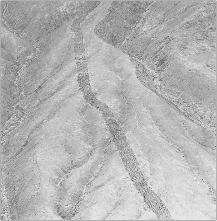
Detailed drone imagery reveals that Monte Sierpe contains approximately 5,200 holes, aligning with previous estimates. These holes are grouped into several sections, separated by empty spaces and distinguished by variations in both the number of holes and their construction styles—for example, some have stone walls while others do not. The differing hole counts and structural features across these sections suggest a deliberate organizational plan underlying the site’s layout.
The research team emphasizes the importance of distinguishing between morphological similarities and functional equivalence when comparing Monte Sierpe to other constructed features worldwide. For instance, while bands of shallow holes (hulbæltet) were sometimes used as defensive structures in Iron Age European settlements (500 BC–AD 0), there is no evidence at Monte Sierpe of fortifications, attacks, defensive measures, or typical weapons such as slingstones (bolas) found at other fortified Andean sites.
Additionally, comparisons have been made with features like the shallow pits for grape cultivation in Lanzarote (Canary Islands), fog or water capture systems, and sunken fields elsewhere in the Andes. However, these hypotheses are not strongly supported. Rainfall is virtually absent at Monte Sierpe’s altitude in the Pisco Valley, and Andean sunken fields typically depend on groundwater—which is unavailable on Monte Sierpe’s slope. Although the site lies within an area that occasionally experiences brief fog oases (lomas), any captured fog would not provide enough water to sustain most plant species identified at Monte Sierpe. Furthermore, the nearby Pisco River supplies ample water for agriculture throughout the year without relying on fog capture.
Finally, since no human remains—apart from a few intrusive tombs—were found at the site and there is no evidence of copper or silver ores present, it appears unlikely that Monte Sierpe served as a burial ground or mining area. It would seem the site had a different purpose.
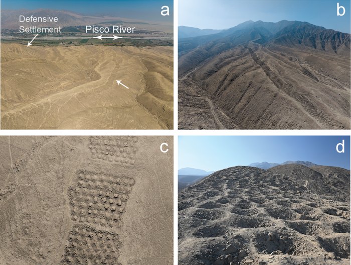
Monte Sierpe: a–c) aerial photographs of the Band of Holes and its surrounding environment; d) ground-level photograph of the holes. Credit: J.L. Bongers
The most significant discovery from the new study is microbotanical evidence found within the holes—remnants of plants such as maize and wild species traditionally used for basket-making—which suggests these features played a role in agricultural processing or trade among ancient Inca communities.
“These data support the hypothesis that during pre-Hispanic times, local groups periodically lined the holes with plant materials and deposited goods inside them, using woven baskets and/or bundles for transport,” explains Dr. Bongers.
An aerial photograph of Monte Sierpe taken by Robert Shippee and published by the National Geographic Society in 1933 (photograph reproduced courtesy of the American Natural History Museum; AMNH Library negative no. 334709
Aerial imagery of Monte Sierpe reveals intriguing numerical patterns in the arrangement of its holes, which, when considered alongside the monument’s segmented organization, closely resemble khipus—Inca counting devices made from knotted string. This similarity suggests that Monte Sierpe may have functioned as a large-scale accounting system during the Inca period, potentially managed by state authorities for tribute collection.
Monte Sierpe’s location further supports this interpretation. It sits strategically between two Inca administrative centers and near a crossroads of pre-Hispanic road networks. The site is situated in the chaupiyunga, a transitional ecological zone between highlands and coastal plains where groups from both regions likely met to exchange goods.
Taken together with microbotanical evidence and aerial analysis, these findings indicate that Monte Sierpe was originally built and used by the pre-Inca Chincha Kingdom for regulated trade and barter. Over time, it appears to have evolved into an important accounting center under Inca administration.
See also: More Archaeology News
“This study contributes an important Andean case study on how past communities modified past landscapes to bring people together and promote interaction,” Dr. Bongers concludes. “Our findings expand our understanding of barter marketplaces and the origins and diversity of Indigenous accounting practices within and beyond the ancient Andes.”
The study was published in the journal Antiquity
Written by Conny Waters – AncientPages.com Staff Writer