Jan Bartek – AncientPages.com – Easter Island (Rapa Nui), situated in the heart of the South Pacific and thousands of miles from the nearest continent, is renowned as one of the world’s most remote inhabited locations. Traditionally, visiting this unique island and witnessing its famous moai statue quarries has been a rare privilege. However, recent advancements have made this experience more accessible.

The new 3D model, made possible by Binghamton researchers, lets visitors explore the main quarry of Easter Island, home to nearly 1,000 moai statues. Image Credit: Carl Lipo.
A research team that includes faculty from Binghamton University has developed the first high-resolution 3D model of Rano Raraku, one of Easter Island’s primary quarries. This digital innovation allows people around the globe to virtually explore the site and view nearly 1,000 iconic moai statues from their own homes.
“As an archeologist, the quarry is like the archeological Disneyland,” said Binghamton University Professor of Anthropology Carl Lipo and lead author of a new paper in PLOS One. “It has everything you can possibly imagine about moai construction, because that’s where they did most of the construction. It’s always been this treasure of information and cultural heritage, but it’s remarkably underdocumented.”
“You can see things that you couldn’t actually see on the ground. You can see tops and sides and all kinds of areas that just would never be able to walk to,” said Lipo.
Lipo said that the 3D model opens the door for things that were never possible: 1) it provides researchers with a three-dimensional replica that they can study and 2) it allows everyone to experience the island.
“We can say, ’Here, go look at it.’ If you want to see the different kinds of carving, fly around and see stuff there. So it’s really exciting to bring these two things together. We’re documenting something that really has needed to be documented, but in a way that’s really comprehensive and shareable.”
Mapping The Island
In October 2023, a wildfire swept through the quarry, prompting concerns about the site’s long-term preservation. When archaeologist Lipo and his team arrived in January 2024 to continue their research, a local community group requested that they document the quarry in case it suffered permanent damage.
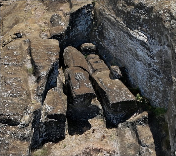
Unfinished moai attached to bedrock by “keels” along their backs demonstrate how carvers worked underneath from both sides until figures were separated from the source material. This production stage, difficult to document through traditional methods, is visible in the 3D model. Image Credit: Carl Lipo.
The research team, which included Thomas Pingel and Kevin Heard from Binghamton University’s Geography Department, responded promptly to this request. They conducted approximately 30 drone flights over the area, capturing around 22,000 photographs at 30-meter intervals. These images were then processed with specialized software to create a detailed 3D model of the quarry—a task that took several months to complete.
“It’s amazing how far and how fast the technology has come,” said Pingel. “The quality of this model is far above what could be done even just a couple of years ago, and the ability to share such a detailed model in a way that is accessible from anyone’s desktop computer is remarkable.”
“The project was of a scale of complexity that had never been attempted before,” said Lipo.
Putting The Map To Use
Using the new 3D model, the researchers examined the sites of 30 different “workshops” in the quarry. Examining the patterning of the quarrying, where carving techniques differed from site to site, the researchers found it aligned with previous evidence – that the island consisted of multiple independent groups working simultaneously rather than being managed by a centralized “chiefdom.”
“We see separate workshops that really align to different clan groups that are working intensively in their specific areas,” said Lipo. “You can really see graphically from the construction that there’s a series of statues being made here, another series of statues here, and that they’re lined up next to each other. It’s different workshops.”
While this theory isn’t necessarily brand-new, Lipo said it’s nice to see the evidence baked into the quarry itself.
“When we look at the ability for people to move giant statues, it doesn’t take that many people to do it, so that it really connects all the dots between the number of people it takes to move the statues, the number of places, the scale at which the quarrying is happening and then the scale of the communities,” said Lipo.
In the future, the researchers will utilize the 3D model for further analysis of the quarry. Lipo also hopes that people will use the model, from researchers to laypeople alike.
See also: More Archaeology News
“What we would really like to do is be able to say, ‘Go visit it yourself. Learn from it.’ People on the island are afraid that if we build three-dimensional models that no one will go to the island. But I think this actually will inspire people to go there. Because otherwise, you’re just seeing sort of snapshots of stuff. This is an incredible landscape of stuff that you could really go visit, that you’ll want to see.”
The 3D model is available to view online.
The study was published in the journal PLOS One
Written by Jan Bartek – AncientPages.com Staff Writer